


Click on any image below to see it on a new screen where you may be able to download it. You also can use Print Friendly, which will allow you to save the page as a pdf file. To do that, click the printer icon ![]() in the vertical Social Media bar on the far left edge of this page.
in the vertical Social Media bar on the far left edge of this page.
See also the collection of maps in the Palestine Teaching Trunk.
All Map Pages:
• Maps “home page” – includes map of The Middle East
• Ottoman Empire through 1949
• 1967 to the present
• Jerusalem
• Bethlehem (coming soon)
• Area C/ Jordan Valley (coming soon)
• Loss of Land
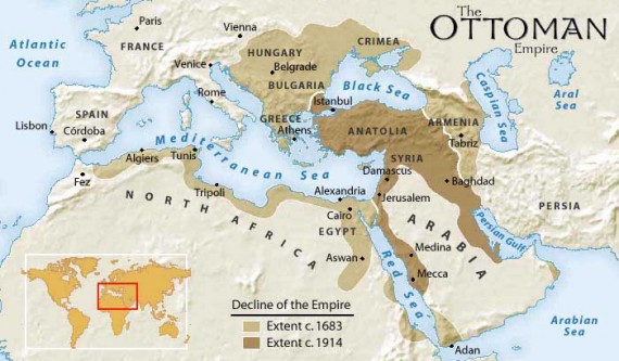
Above: This map shows in dark brown the Ottoman Empire’s territory in 1914, at the beginning of WWI. This empire included Palestine – see the location of Jerusalem. By the end of WWI, the Ottomans, who were allied with the Germans, had been defeated, and the empire was broken up.
In 1915, during WWI, the British High Commissioner in Egypt, Sir Henry McMahon, had corresponded with Prince Hussein of Arabia, and had promised that Britain would support independence for Arabs who lived under Ottoman rule after the war, if the Arabs would help the Allies in fighting the Ottoman Turks, which they did quite successfully. Many readers will be familiar with the film Lawrence of Arabia which shows some of the events of this period, including the Arabs’ expectation of independence from foreign rule if the Ottomans were defeated.
In 1917, in contradiction of Britain’s promise to the Arabs, the British Foreign Secretary Lord Balfour promised British Zionists that Great Britain would support the establishment of a Jewish homeland in Palestine, which was then a part of the Arab region ruled by the Ottoman Turks.
In 1916, in contradiction of promises both to the Zionists and the Arabs, Britain entered into the secret Sykes-Picot agreement with France (see the next map).
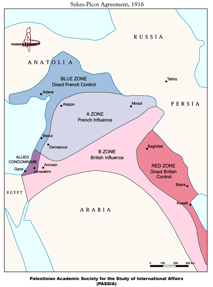
Above: This map title refers to the secret agreement between Great Britain and France during WWI, made by two diplomats named Sykes (acting on behalf of the British) and Picot (acting on behalf of the French). It shows the areas that Great Britain and France agreed they would control after the Ottoman Empire was defeated and broken up. The area in purple includes much of what is now Israel/Palestine. See notes for the previous map regarding the three contradictory promises about this land that were made by Britain during the period of WWI.
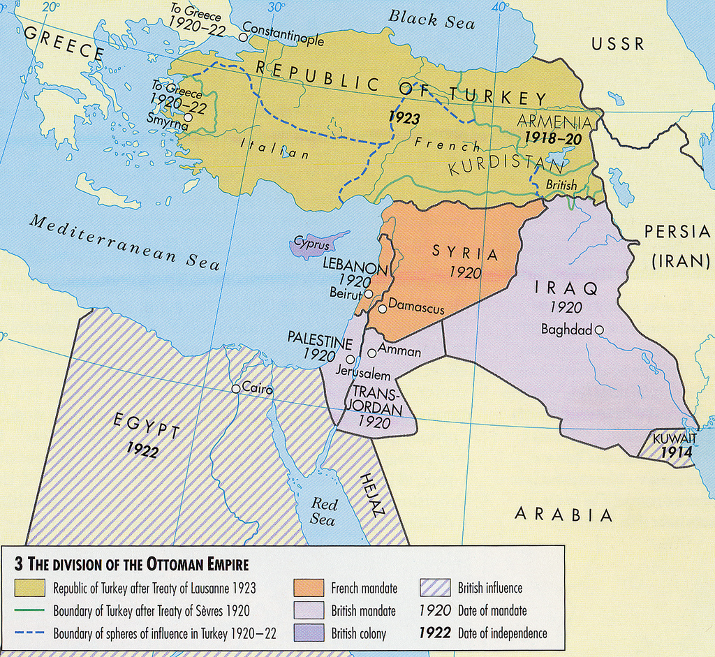
Above: This map shows the lands of the former Ottoman Empire. After the end of WWI, the League of Nations (a precursor to the United Nations) was established and, in 1922, they designated portions of the former Ottoman Empire to be controlled by Great Britain and France, largely according to what these two powers had determined in the Sykes-Picot Agreement. The light lavender area was designated for British control.
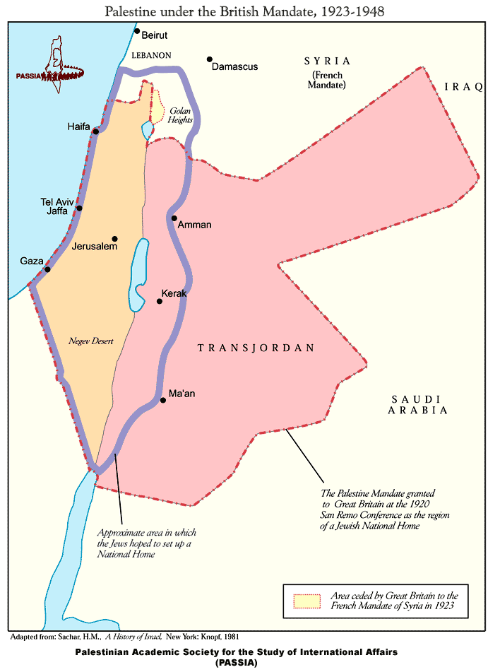
Above: This map is a closer view of the region designated for the British Mandate after WWI: all of the light brown and pink areas. The purple border shows the area in which Zionists had hoped to establish a Jewish state. The name of TransJordan (the pink area) later changed to Jordan.

Above: In this map of Palestine at the beginning of the British Mandate period, the blue dots show towns or small colonies that were Zionist, the black dots had mixed populations and all the red dots were Arab Palestinian villages and towns. The significance of this map can be found in comparison to the dramatic change in population achieved in the next two to three decades by massive Zionist immigration.
Note that this map cites 1920 as the beginning of the British Mandate period, and in practical terms it did begin then, although it was not officially established by the League of Nations until 1922.

Above: This map shows the population distribution of Palestine in 1946, the year before the UN Partition Plan was proposed. The round pie-charts show the proportions of Arab and Jewish populations in all the regions of Palestine, the green sections of the circles being Arabs and the blue sections being Jewish. Altogether, the Jewish population comprised about one third of the Palestine’s population at this time. Comparing this to the previous map, clearly there were now a lot more Jewish residents in many more parts of Palestine than there had been 26 years earlier, in 1920. This was accomplished through large waves of immigration organized by the Zionist movement with the goal of establishing a state by and for Palestine’s Jewish inhabitants.
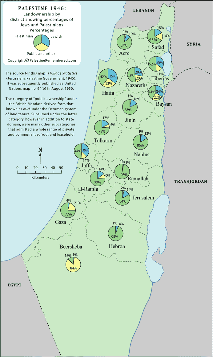
Above: This map’s pie-charts show land ownership in Palestine in 1946, one year before the UN Partition Plan was adopted. At this time Jewish ownership of land comprised about 7% of Palestine.
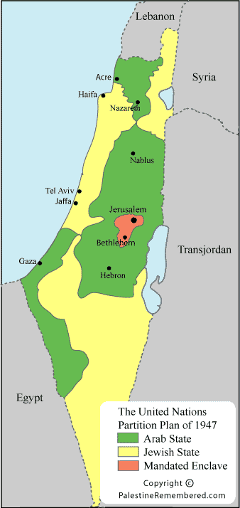 Left: This map shows the boundaries of the partition of Palestine that the UN proposed in 1947, with Resolution 181: the yellow area was to be a Jewish state (56% of Palestine) and the green area was to be an Arab state (44% of Palestine). It is a common misconception that the UN thereby “created” the State of Israel with Resolution 181. However they did not have the power or authority to do that. This was simply a proposal by the two-year-old United Nations; notably it was made in contradiction of the known wishes of the Arab majority, who were two thirds of the residents of the land in question.
Accordingly, this proposal was rejected by the Arab League. They saw no justification for allocating 56% of Palestine to the Zionists who comprised 33% of the population (see map above), who owned about 7% of the land (see map above), and whose population had grown to 33% from being at most 7% of the population in 1900 (see maps above) only through massive immigration that was planned – according to Zionist leaders’ statements and writings – for the purpose of taking over Palestine and dispossessing the indigenous population of their land.

Above: The map on the left shows the UN’s proposed Partition Plan of 1947: the blue area was to be a Jewish state (56% of Palestine) and the beige area an Arab state (44%). (See more above about the partition plan and why it was rejected by the Arab League.)
The map on the right shows the borders that existed after the war of 1948-49 (called the “War of Independence” by Israelis, the “Nakba” (the “catastrophe”) by Palestinians. Both the blue and purple areas were controlled by Israel and the beige area is what remained under Arab control. Now 78% of Palestine was lost to the Arabs of Palestine. The West Bank (called that because it is land to the west of the Jordan River) and the Gaza strip – the two beige areas – comprise 22% of historic Palestine; that is all that remained for a possible Palestinian state.
Today the international community accepts these borders (the combination of all the blue and purple area) as the State of Israel’s recognized borders under applicable international law such as the 4th Geneva Convention. The Palestine Liberation Organization (PLO), the official representative of the Palestinian people in the peace talks that began in the 1990’s, also accepted the existence of Israel within these borders of the 1949 Armistice (on this map, it is called the Rhodes Armistice, having been signed in Rhodes, Greece).
These same borders are often referred to as the “1967 borders,” which actually means the first half of 1967. It was in June of that year that Israel took over all the remaining land that Palestinians had: the West Bank and Gaza.
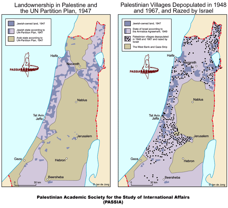
Above: These two maps also compare the borders of the proposed UN Partition Plan in 1947 and the 1949 Armistice borders. In both maps, the lighter lavender area is the area for Israel; the darker lavender areas within that are the locations of Jewish-owned land.
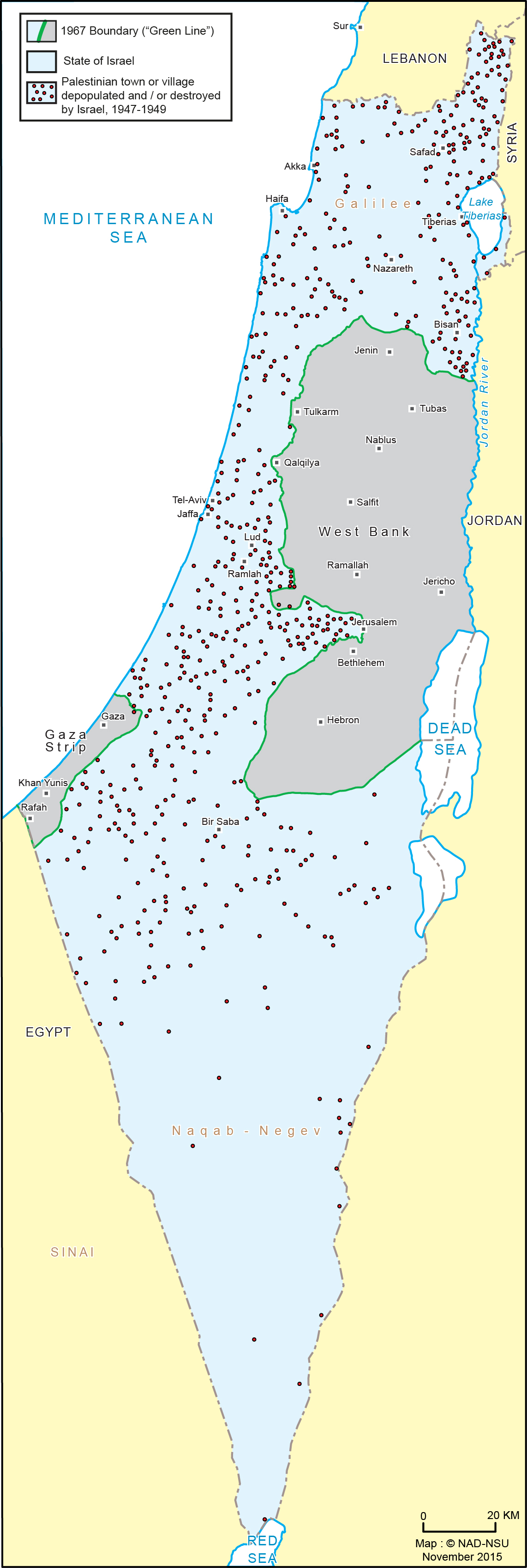
The map on the right shows many of the Arab Palestinian towns and villages that have been depopulated of Arabs and/or destroyed by Israel. The dots on a map this size cannot show the full range of destruction, which includes hundreds of Palestinian towns and villages.
All the Palestinian refugees from these communities, estimated to be about 750,000, had the inalienable right under international law to return to their homes after the fighting ceased. Israel committed a serious crime by destroying their homes and communities and not allowing the refugees to return to their land. This intentional ethnic cleansing of Palestine is the Nabka, the catastrophe that befell the Palestinian people. It continues today with the illegal colonization and ethnic cleansing of the West Bank, under the Israeli military occupation that began in 1967.
Above: This map includes the entire area of Israel/Palestine and shows more of the hundreds of Palestinian towns and villages destroyed in The Nakba.
All Map Pages:
• Maps “home page” includes map of The Middle East
• Ottoman Empire through 1949
• 1967 to the present
• Jerusalem
• Bethlehem (coming soon)
• Area C/ Jordan Valley (coming soon)
• Loss of Land
See also the collection of maps in the Palestine Teaching Trunk.