


Click on any image to see it on a screen where you may be able to download it. You also can use Print Friendly, which will allow you to save the page as a pdf file. To do that, click the printer icon ![]() in the vertical Social Media bar on the far left edge of this page.
in the vertical Social Media bar on the far left edge of this page.
See also the collection of maps in the Palestine Teaching Trunk.
All Map Pages:
• Maps “home page” – includes map of The Middle East
• Ottoman Empire through 1949
• 1967 to the present
• Jerusalem
• Bethlehem (coming soon)
• Area C/ Jordan Valley (coming soon)
• Loss of Land
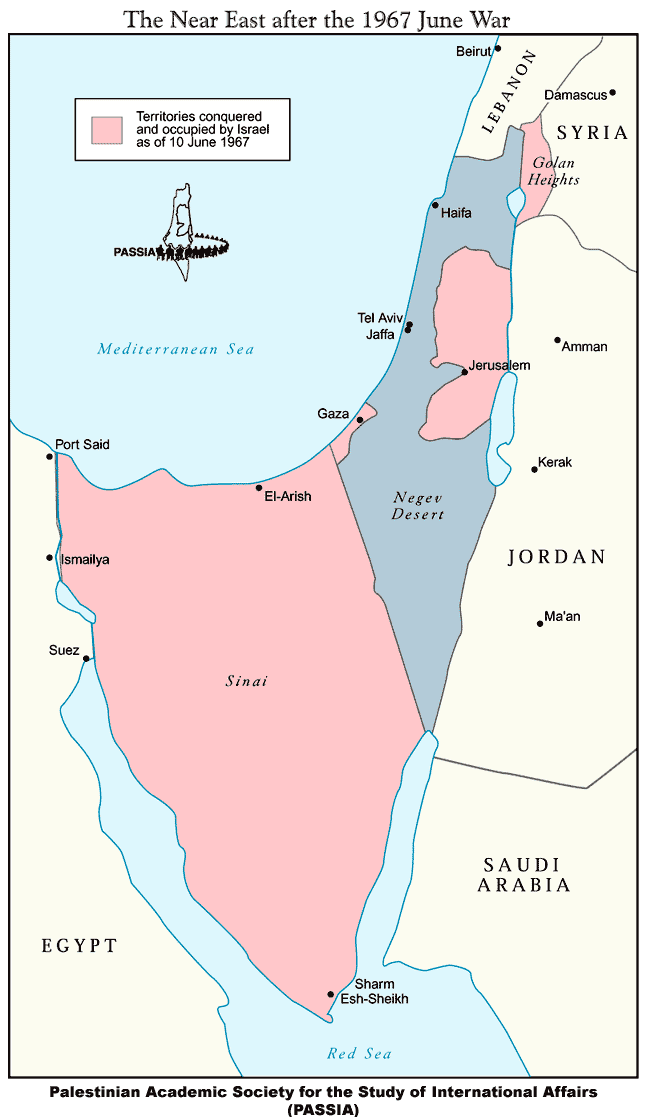
Above: The war of June 1967 began with a pre-emptive air strike by Israel in which it destroyed the air force fleets, while they were on the ground, of three neighboring nations, Jordan, Syria and Egypt. Without air capability these nations had little ability to defend their territories and this war ended quickly: it is known as the Six Day War. At the end of this war, Israeli forces had occupied all the areas in pink on this map: the West Bank, Gaza, the Golan Heights which belonged to Syria (at the northeast/upper right corner of Israel) and the Sinai Peninsula which belonged to Egypt (large area to the left/southwest of Israel).
The Camp David Accords, mediated by U.S. President Jimmy Carter, were fulfilled in 1982, at which time all of the Sinai Peninsula was again under Egyptian control.
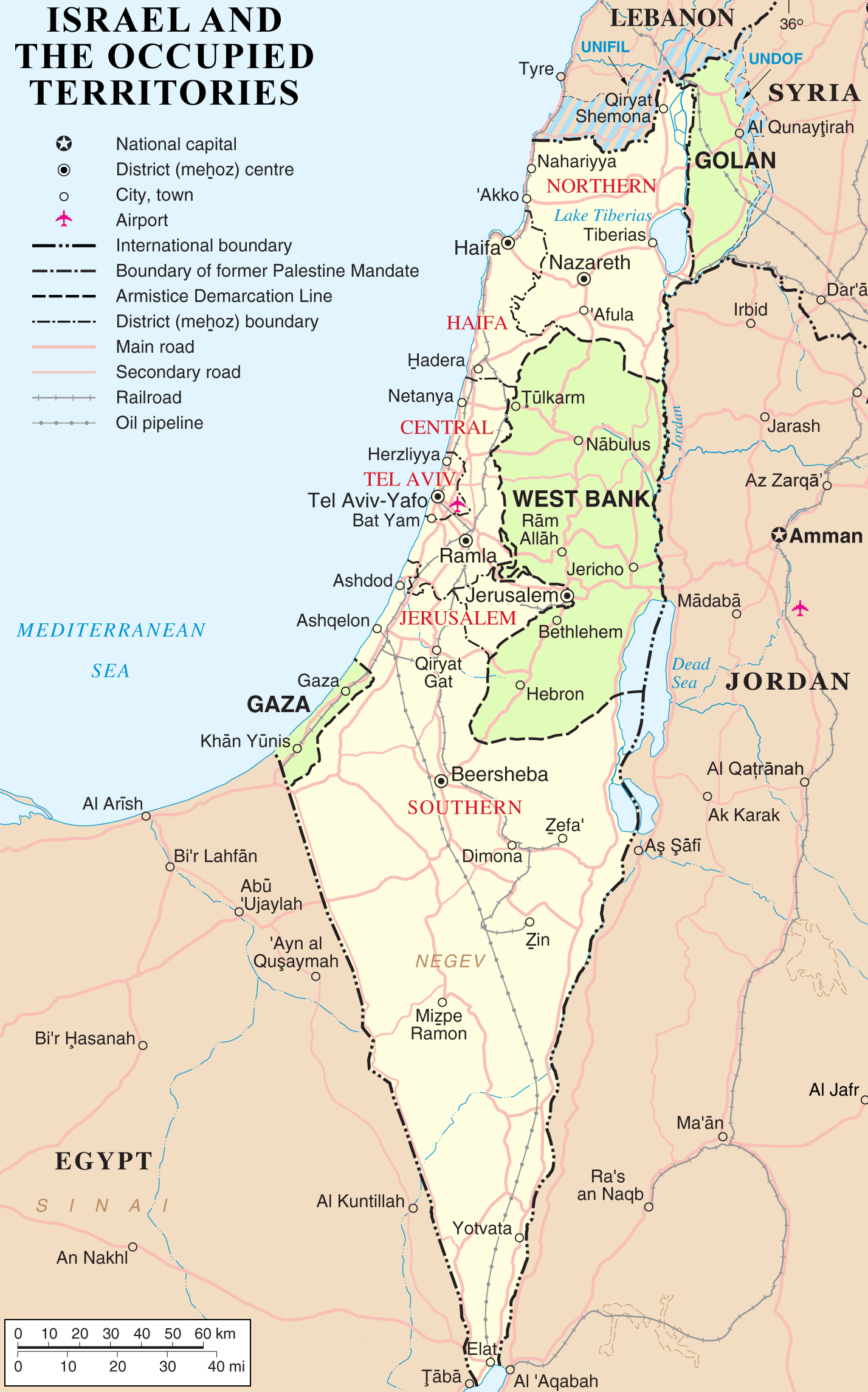
Above: This map shows in green the areas that Israel has had under military occupation since 1967. As noted in the previous map, the Sinai Peninsula was returned to Egyptian control by 1982.
In November 1967, the same year as the Six Day War, the UN Security Council unanimously adopted UN SC Resolution 242, which required the “withdrawal of Israeli armed forces from territories occupied in the recent conflict.” As of 2017, Israel has refused to comply with this UN Security Council resolution for fifty years.
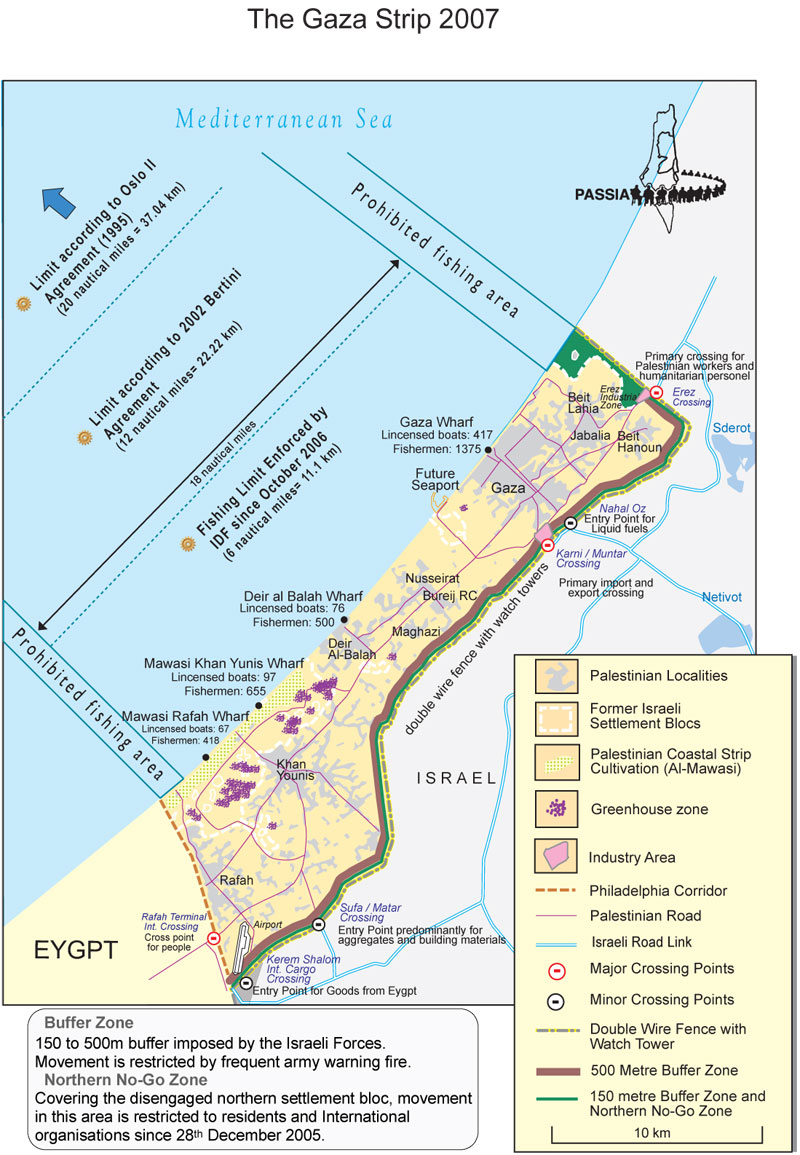
Above: Gaza is part of the territories under military occupation by Israel since the Six Day War of 1967. Although Israeli settlers and troops were withdrawn from Gaza in 2005, it is still considered occupied territory under international law because Israel still controls the lives of the inhabitants of Gaza. Israel maintains a blockade by land and sea on three sides. Egypt controls a small portion of Gaza’s border, to the south, in cooperation with Israel and Israel’s primary protector state, the USA; Egypt is the world’s second largest recipient of US aid.
By sea, Gazans are blockaded by the Israeli Navy. Gazan fisherman may travel only to the first dotted line seen on this map, an area that falls far short of the distance agreed under the Oslo Accords and that has become insufficient for them to maintain their livelihoods. Fisherman are frequently confronted and even attacked by the Israeli Navy.
Humanitarian ships that have tried to break the blockade of Gaza have also been attacked by Israel. Learn more about Gaza and the Freedom Flotillas here.
The circles on the land borders in this map show the checkpoints which are the only places Gazans may exit their territory or by which goods can be brought into Gaza. Since the massive Israeli assaults on Gaza – Operation Cast Lead in December 2008-January 2009, Operation Pillar of Defense in the summer of 2012, and Operation Protective Edge in the summer of 2014 – the materials needed to rebuild tens of thousands of destroyed homes, as well as hospitals, utilities providers, schools, and businesses, are not being allowed into Gaza. The United Nations has repeatedly called for additional aid for Gazans and for a loosening or end to the blockade. The UN estimates that 80% of the people in Gaza are dependent on humanitarian aid for survival, and 90% of the ground water in Gaza is unfit for human consumption. The World Bank puts Gaza’s unemployment rate at 43%, the highest in the world. Gaza’s only power plant has been damaged repeatedly by Israeli bombardment and can provide electricity for Gazans only a few hours a day.
In 2016, Gaza’s population reached two million, making it one of the most densely populated areas on earth; it has often been called “the largest open-air prison in the world.” Besides severely limiting entry of food, water and other essential resources, as well as desperately needed building materials, the imprisonment of Gaza denies patients access to urgent medical treatment beyond their territory, keeps students from pursuing educational and career opportunities abroad, divides families who are located in Gaza and the West Bank, and prohibits the international community, including the press, from adequately monitoring and reporting on this continuing humanitarian disaster.
Israel always cites the actions and statements of Hamas, the ruling party in Gaza, as justification for its repeated and merciless bombardments and its decade-long blockade of the population that it keeps imprisoned in this territory. Nevertheless, it should be clear to principled observers that no actions by a government or militant group could justify this brutal collective punishment of two million captive people.
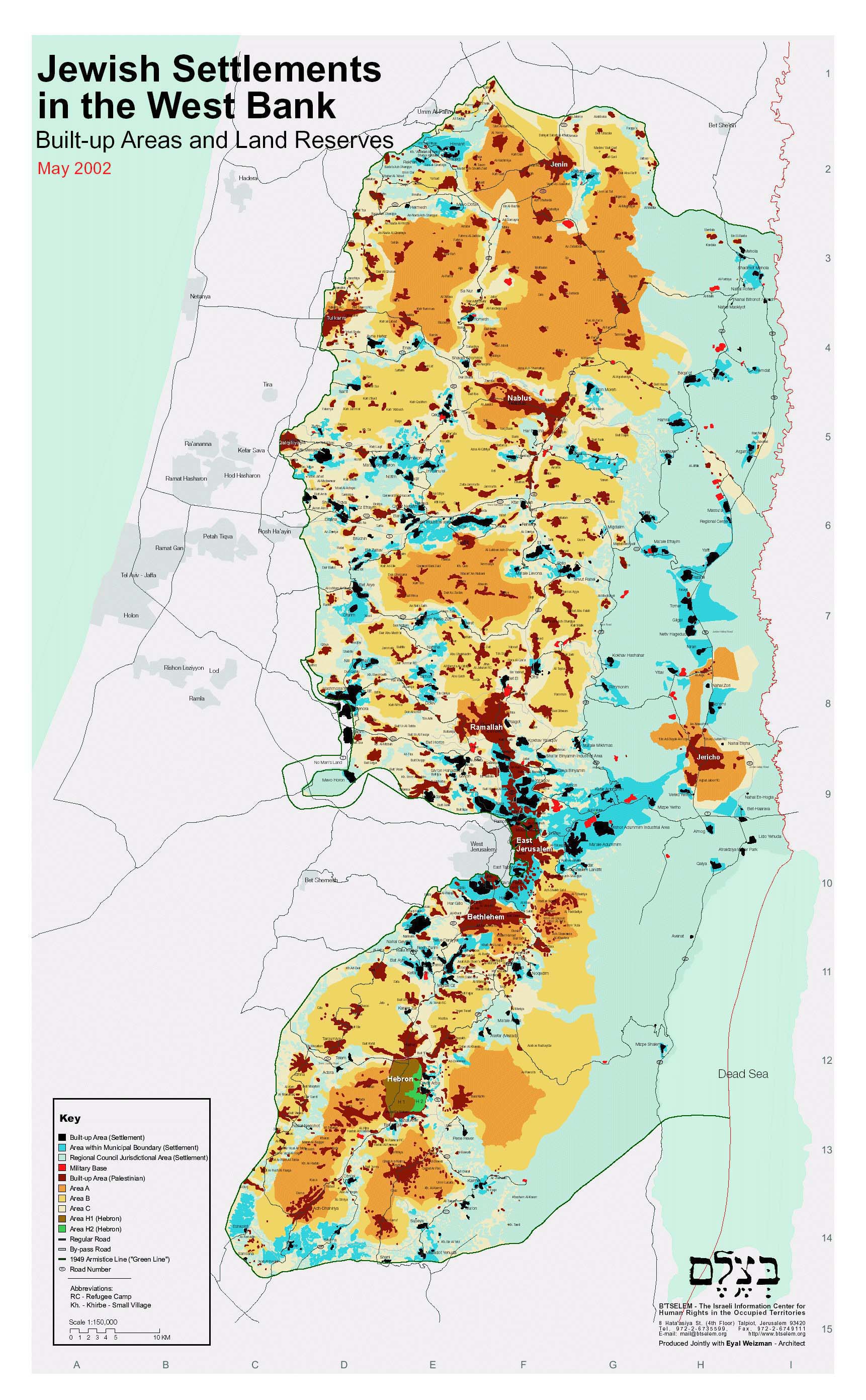
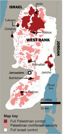
Above: This detailed map shows the fragmentation of the West Bank in 2002. Over a decade later, the settlement areas and their populations have greatly expanded.
![]() The bright aqua areas are Israeli settlements.
The bright aqua areas are Israeli settlements.
![]() The strong orange/brown areas are Area A, the only areas under full Palestinian administration.
The strong orange/brown areas are Area A, the only areas under full Palestinian administration.
![]() The medium yellow/beige areas are Area B where the Palestinians have civil authority, but Israelis maintain security control.
The medium yellow/beige areas are Area B where the Palestinians have civil authority, but Israelis maintain security control.
![]() The areas in the lightest yellow/ivory, as well as all the the pale blue and pale green areas, are completely controlled by Israel.
The areas in the lightest yellow/ivory, as well as all the the pale blue and pale green areas, are completely controlled by Israel.
![]() The darkest red areas are those most built up by Palestinian development, but other areas are equally significant for Palestinian land ownership and agriculture.
The darkest red areas are those most built up by Palestinian development, but other areas are equally significant for Palestinian land ownership and agriculture.
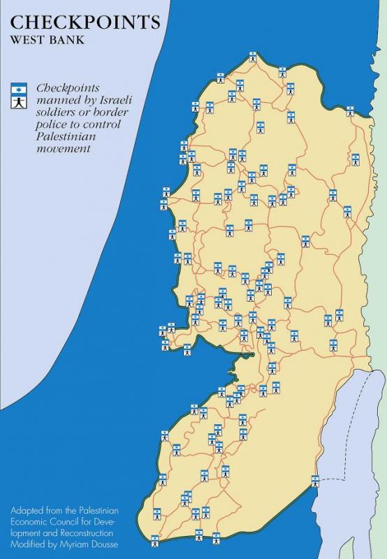
Left: This map shows the proliferation of Israeli checkpoints throughout the West Bank. The locations of checkpoints, roadblocks, agricultural gates and other obstacles have changed periodically over the years of occupation, but there continue to be hundreds of such hindrances to Palestinian’s essential freedom of movement.
Only a handful of checkpoints control Palestinian access to the state of Israel. All the rest bar Palestinian movement within their own territory, cutting them off from family members, hospitals, schools and jobs. This systemic restriction of movement makes a normal life impossible for the entire population living under occupation and strangles the Palestinian economy.
This systemic control of movement enables the occupying power to control a population that might otherwise be able to organize and challenge the ongoing colonization of their land.
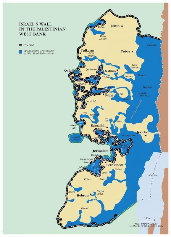
Left: This map shows the planned route of the Separation Wall, also called the Separation Barrier, the Security Fence and the Apartheid Wall. Israel began building the Wall in 2002, and it is not finished; roughly 2/3 or more has been completed. As this map shows, Israel is not building the Wall on its internationally recognized border – the border from the 1949 Armistice, also called the Green Line. Instead, 85% of the wall’s route is in occupied Palestinian territory, thereby illegally annexing to Israel the areas that have seen the most colonization by the Israeli settlements. All of the blue area in this West Bank map is under full Israeli control. Tens of thousands of Palestinians are now trapped to live in the “seam zone” – the area between the wall to the east and the border of Israel to the west.
In 2004, the International Court of Justice issued a finding that the Wall is illegal under international law, construction must stop immediately, and Israel should make reparations for damage to Palestinian homes and property caused by the building of the wall. The ICJ also said that all States should not accept “the illegal situation resulting from the construction of the wall” and should not give any aid or assistance in maintaining that situation. The UN General Assembly has also called for the Wall to be dismantled.
Above: This map provides a clear view of the fragmentation of the occupied West Bank, caused by illegal Israeli colonization. Both the beige and the teal areas are under Israeli control, only the white area is considered to be under Palestinian control. These white areas cannot provide the Palestinian people with a viable state of contiguous (connected) territory.
Left: A simpler, vivid illustration of the fragmentation of the West Bank.
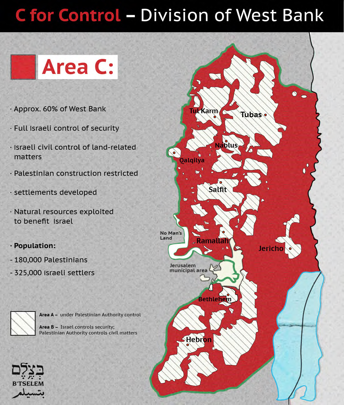
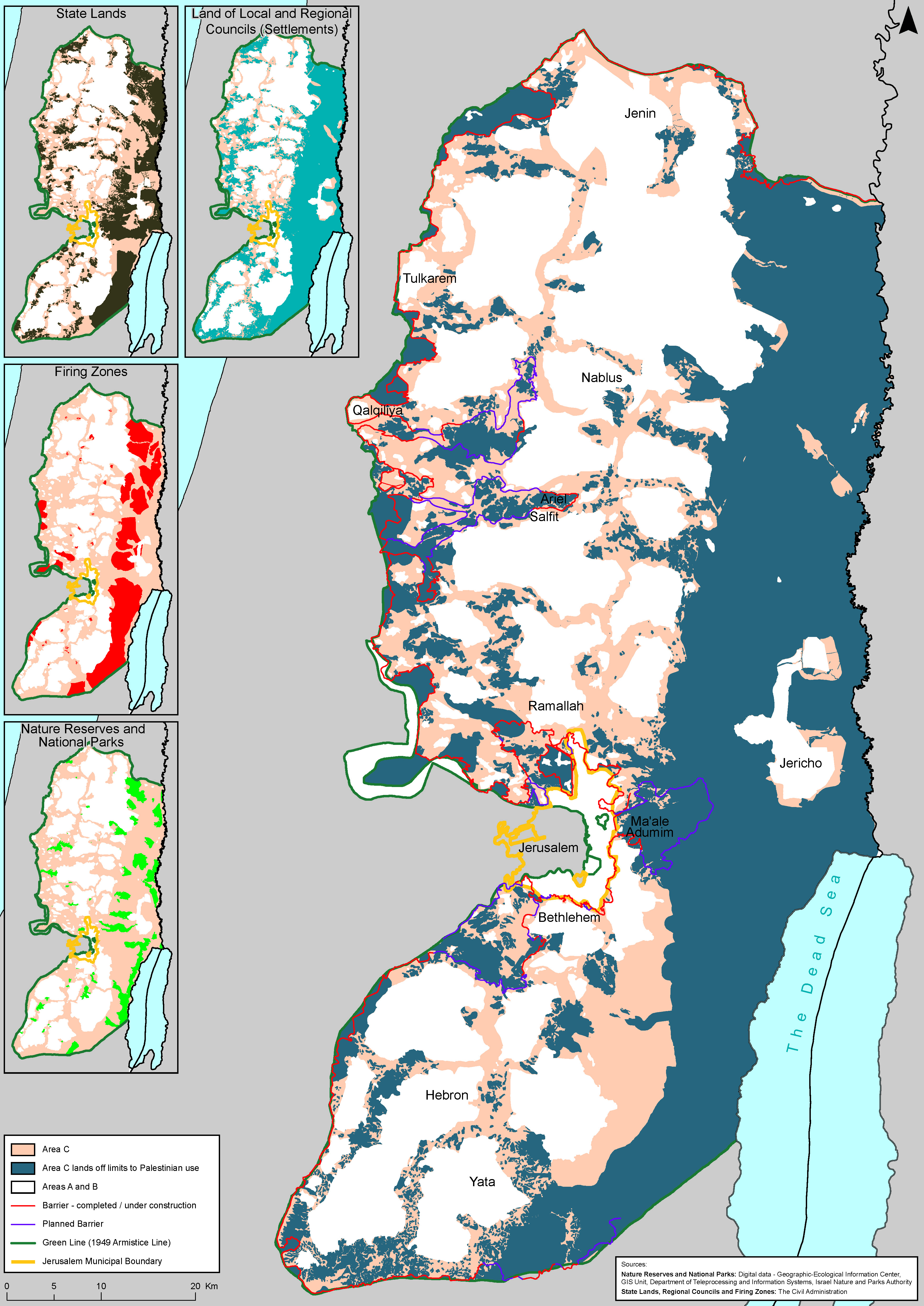
Above: B’Tselem’s map of Area C also shows the fragmentation of the West Bank under the Israeli occupation and the small percentage of land left for Palestinians (Areas A and B). The statistics on settlers are probably higher than quoted here and is rising monthly as Israel continues with aggressive expansion of existing settlements and establishment of new ones.
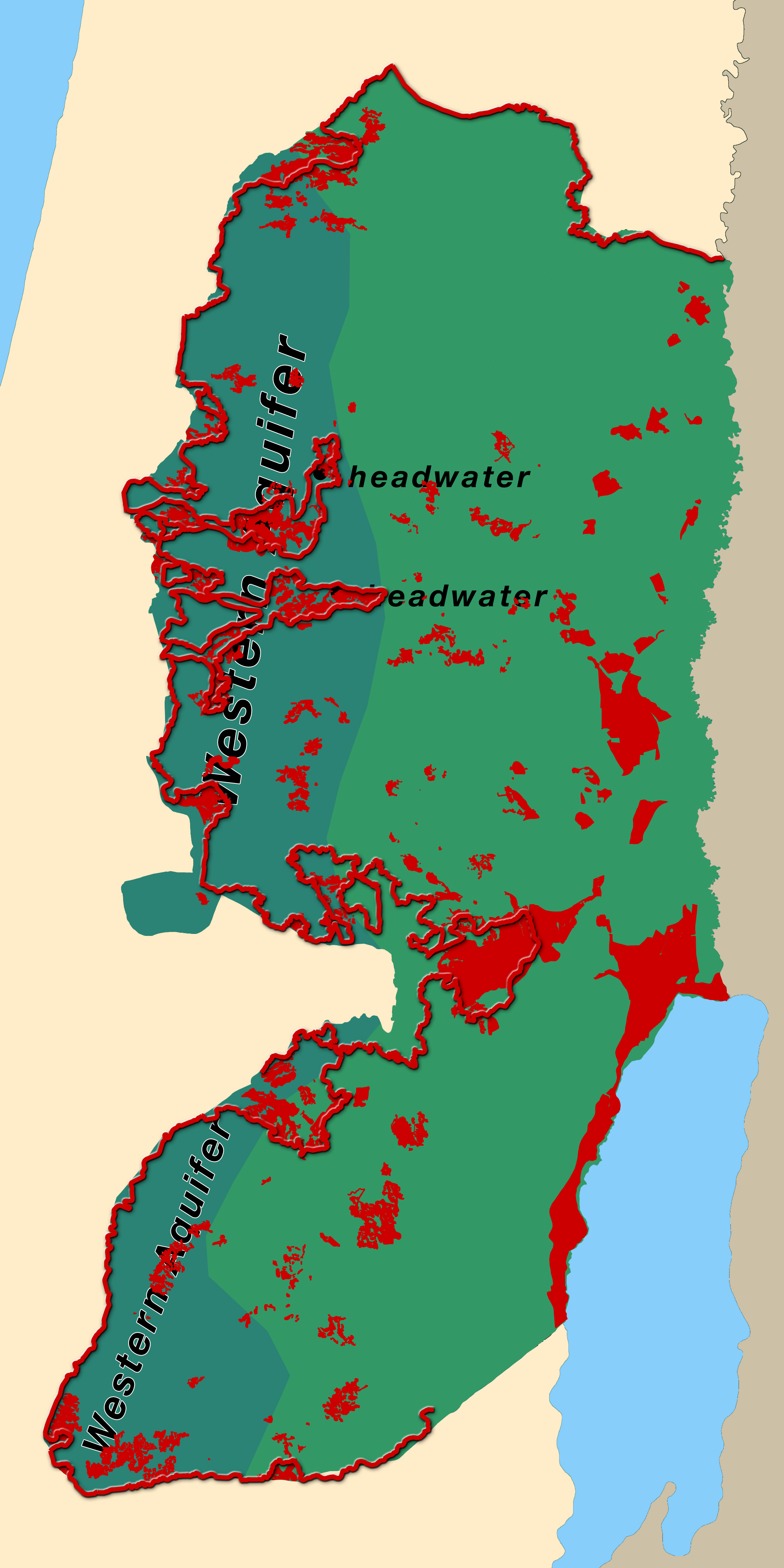
Above: This map helps to illustrate one of the key issues of the Israeli occupation, an issue that must be addressed in any peace settlement: Water. The dark teal green area is the underground aquifer which is a prime source of water for this region. The red line and red areas are the Separation Wall and Israeli settlements, which are drawing heavly from the aquifer, not only for the settlements but for Israeli itself. Analysts estimate 80-85% of the water Israel takes from the West Bank is allocated to the settlers and to Israel, leaving the Palestinians in the West Bank suffering from severe water deprivation.
The UN has stated repeatedly that Palestinians in the West Bank are not receiving the minimum recommended daily amount per capita. They are also paying exorbitant rates for the water taken from their own territory, at much higher prices than their neighbors, the settlers, pay. And the settlers use 4 to 5 times as much water as Palestinians in the West Bank. These Jewish-only settlements have swimming pools, green lawns, and beautiful gardens, while Palestinians who have running water are frequently cut off for days and even weeks.
Hundreds of thousands of Palestinians in the West Bank live in communities that have not been included in the water infrastructure, and they have no running water in their homes, or for their livestock and farmland, a severe hardship. They must depend on trucks to bring in water, or local wells and cisterns. Every year, Israel destroys dozens of Palestinian wells and cisterns to maintain control of all water in the West Bank.
All Map Pages:
• Maps “home page” includes map of The Middle East
• Ottoman Empire through 1949
• 1967 to the present
• Jerusalem
• Bethlehem (coming soon)
• Area C/ Jordan Valley (coming soon)
• Loss of Land
See also the collection of maps in the Palestine Teaching Trunk.